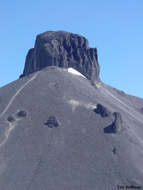
The Black Tusk from near "Outhouse Junction"
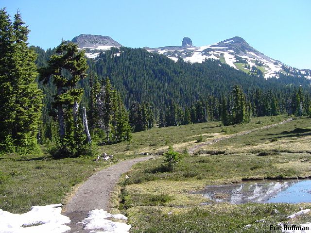
Okay, I was on vacation. My longest in a long, long time. I had 10 straight days off and didn't want to waste an entire day traveling so I hit the road on a warm, sunny evening. Destination: Whistler, British Columbia. Actually, I was planning on stopping a bit before that, at the Black Tusk Trailhead. The turn-off is located between Squamish and Whistler and like most trailheads in the area, it is well signed. The turn-off is paved to the large parking area at the trailhead where the crowds gather.
This is basically a scenic hike north of Mount Garibaldi and Garibaldi Lake. The park's trail system takes you to the "Black Tusk Viewpoint", where a sign states that climbing the Black Tusk is not recommended due to loose and falling rock. There is a shorter way to reach The Black Tusk than following the trail to the viewpoint, but this route ascends the least amount of steep scree. There is 50 to 100 feet of loose class 3 in a chimney on the SW corner of the tusk. Above this the route is on easy talus. I did not actually reach the true summit of the tusk (10-15 feet higher), however. A rappel into a rotten notch and a very loose class 4 climb gains the true summit just north of where most people, including me, stop. Getting back is said to be even worse. Reportedly, not too many people make the ascent to the true summit. If you get there you will see why, but there was a rappel sling on the summit...
The trail leads gently uphill about 3.5 miles before reaching a fork. The left fork leads to Taylor Meadows Campground and the right fork leads to Garibaldi Lake. I took the left fork and arrived at the campground, about 1.5 miles from the fork. There is a screened shelter and wooden platforms for pitching tents on. Pretty nice for a backcountry camp site. Continuing on another 1.2 miles, I arrived at "Outhouse Junction". This is where the real meadows begin.
|
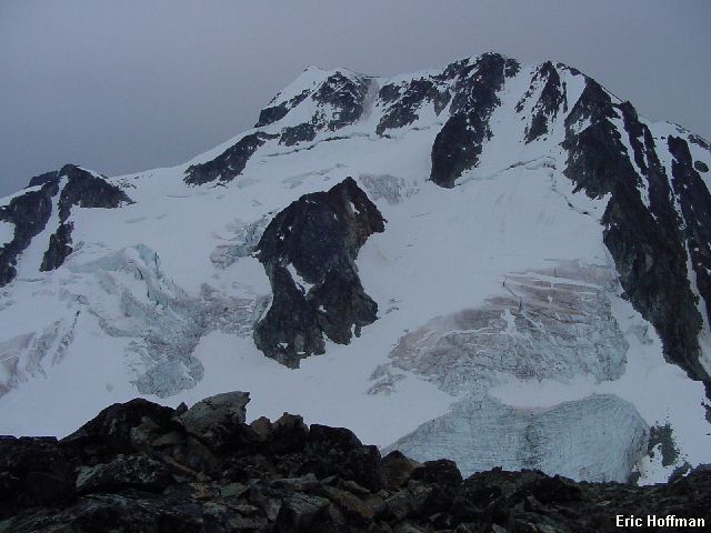
The Black Tusk from near "Outhouse Junction" |
|
|
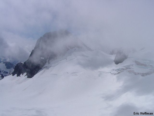
In about another 1.5 miles you arrive at the black tusk viewpoint. From the viewpoint a you get a better idea of just what you are up against...a pile of scree capped by cliffs that look like they are going to be hard to get up. From the viewpoint, a scree trail leads to a ridge that rises to the base of the cliffs. An easy traverse can then be made below the cliffs to the SW corner. The ascent route is visible in the photo below, with the screen ridge on the right and the sw corner being left of center of the Tusk. Once at the the SW corner of the Tusk climb 50-100 feet of loose class 3 in a chimney. Locating the correct Chimney is harder than actually climbing it. When the chimney narrowed, I climbed out on the right and continued up to a bench. From here I spotted an obvious ramp leading to easy travel on talus. The true summit is a bit of a problem, more because it blocks the view to the north than because I'm not on it. The view to the south is of Garibaldi Lake, and Mount Garibaldi and another odd feature, the table.
|
The Black Tusk from the SW |
|
|
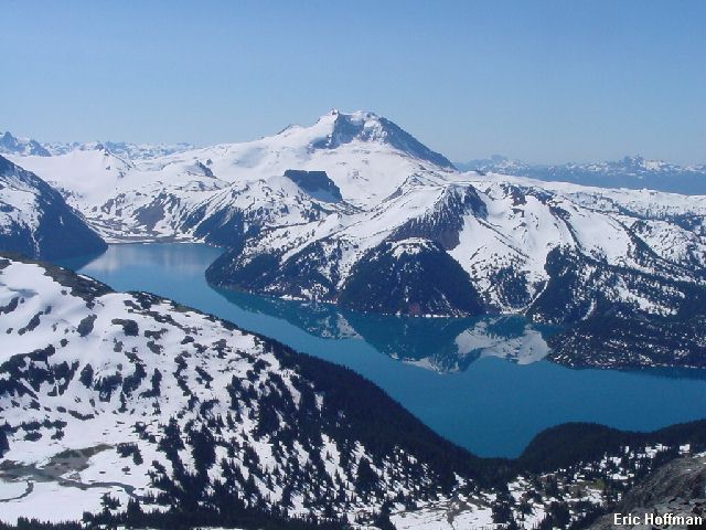
|
Mount Garibaldi and Garibaldi Lake from The Black Tusk |
|
|
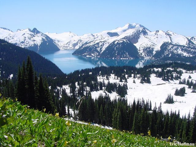
|
Another view of Mount Garibaldi and Garibaldi Lake from south of the Tusk |
|
|
After a long hike back to the trailhead, I headed to Whistler to meet up with Chris Mattson and company. We established base camp in a 4th floor condo at the Aspens in Blackcomb that had no air conditioning and an elevator that broke shortly after our arrival, but there were no mosquitoes, and you didn't have to boil your water before you drank it.
References:
103 Hikes in Southwestern British Columbia; Jack Bryceland and Mary and David
Macaree; Pages 52-53
A Guide to Hiking and Climbing in Southwestern British Columbia; Bruce Fairley;
Pages 53-54
It was about 3:00am when Chris Mattson and I began the 4+ mile hike to Wedgemont Lake. It was early in the morning or very late at night, depending upon your perspective. After a few difficulties following the trail in the dark, we arrived at the lake. There is a small public shelter there, but I wouldn't plan on staying there without a back-up plan. The lake is a great destination all by itself but the trail is a strenuous, gaining 3800 feet in about 4.3 miles. While the lake is a great stopping point, we had more interest in what was at the other end of the lake.
From the shelter we descended to the lake, then continued to the Wedgemont Glacier that ended nearly at the lake. We started up the lower glacier where there was considerably more exposed ice than I expected to see. Our objective was Wedge Mountain. We had decided to try to climb Wedge Couloir (aka West Ridge Variation in the Fairley Guide, aka NW Couloir by locals) but found conditions to be less than ideal and the weather only making matters worse (soupy snow and it was raining) we decide to check out the views from Parkhurst Peak. From the saddle between Parkhurst and Wedge, the ascent of Parkhurst is a talus hike, but offers a great view of Wedge Mountain and the surrounding area.
|
Wedgemont Lake, Wedgemont Glacier, Wedge Mountain and Parkhurst Mountain Parkhurst Peak stands high above Wedgemont Lake while Wedge Mountain looms in the background. The route up Parkhurst ascends the glacier to a saddle between Wedge and Parkhurst. From the saddle the summit is a talus hike. |
|
|
|
Wedge Mountain from the summit of Parkhurst Peak An excellent view of Wedge Mountain is from the summit of Parkhurst Mountain. Only the top of Wedge Couloir is visible in this photo. The lower left skyline is the Northeast Arete. Not visible the photo is a solo climber on the NE Arete nearing the summit. Hmmm.... |
|
|
|
Chris Near the top of Parkhurst In the far distance is The Black Tusk, about to pull a disappearing act. |
|
|
References:
103 Hikes in Southwestern British Columbia; Jack Bryceland and Mary and David
Macaree; Pages 38-39
A Guide to Climbing and Hiking in Southwestern British Columbia; Bruce Fairley;
Pages 65
Both the Fairley Guide and Alpine Select give this route raving reviews. I would tend to agree. After watching the route being soloed the day before, I had to go give it a try. Back on the trail to Wedgemont Lake at a very early hour in the morning, I reached the lake around 4:30am. The squeaky door of the shelter altered me to the fact that there was someone sleeping in it. I continued on. It had been raining lightly on the way to the lake but the rain had now stopped. I reached the glacier and started up. Clouds moved in making navigation a bit more difficult. After locating the correct snow slope leading to the Wedge-Weart Col (7500'), I started up it on a 800 ft rising traverse to a small notch . I was on the arete.
|
Wedgemont Lake from the Wedgemont Glacier |
|
|
The the lower sections of the arete were melted out. Talus lead to a minor highpoint with a cairn. After a short descent, I bypassed a more difficult section of rock on easy block to the left. I reached snow for good at about 8600'. At about 8900' the angle increased. About 200 feet below the summit ridge, the arete melted into a 45 degree snow patch that hadn't completely melted yet (class 4 when it melts out). Once on the summit ridge, easy talus and snow lead to the summit. There was no view. I waited about a half hour before giving up hope that the clouds would break.
I started down the arete. Given the exposure on the arete, it may have been easier to descend with thick clouds than it would have been on a clear day. I reached the first patch of rock and decided to wait and see if I could at least get a reasonable shot of the arete. After nearly an hour I got a chance to take a few photos.
|
The NE Arete of Wedge Mountain |
|
|
|
Lesser Wedge Mountain from 8600' on the NE Arete Located east of Wedge Mountain, it is impressive even if it is "Lesser". |
|
|
References:
Alpine Select; Kevin McLane; Pages 201-205
103 Hikes in Southwestern British Columbia; Jack Bryceland and Mary and David
Macaree; Pages 38-39
A Guide to Climbing and Hiking in Southwestern British Columbia; Bruce Fairley;
Pages 65-66