Arial View of the Olympus Massif (June 5, 2003; From NE)

At 7965, the West Peak of Mount Olympus is the highest in the Olympics. More accurately described as a massif, Olympus holds the vast majority of the Olympic Range's ice. Glaciers include the massive Blue Glacier on the north side, the large White Glacier on the west side, the Hubert Glacier on the south side and the Hoh and Humes Glaciers on the east side. Mount Olympus is an attractive objective, an objective that Sergio Verdina and I could ignore no longer.
|
Arial View of the Olympus Massif (June 5, 2003; From NE) |
|
|
Expect about a four and a half hour drive from the Seattle area whether you take Highway 101 from Hoquiam or the Hood Canal Bridge. We opted to make it a loop, getting to the Hoh River Visitor's Center via the Port Angeles route, but returning through Hoquiam. The scenery is nicer on the way there but you get to see the Pacific Ocean if you go through Hoquiam.
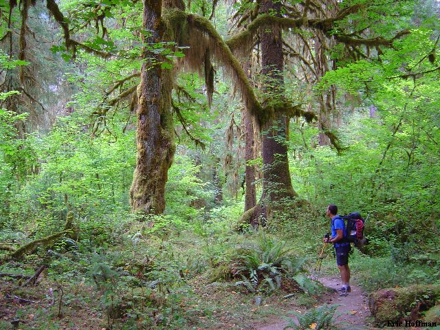
At about 10 minutes past noon, we were ready to begin the 15.1 mile hike to Elk Lake. Permits are required for camping in the Olympic National Park ($5 flat fee and an additional $2 per person per night, there is also a park entrance fee). Permits are available at several locations including the visitor's center in Forks. We headed out from the overnight parking area and began elbowing our way through the crowds of camera toting tourist. After about a mile the tourists thinned out. In about an hour and a half we reached Five Mile island. In another four miles we reached the patrol cabin where we stopped for our first real break. At this point we were hiking mindlessly up the flat trail through the surprisingly dry rainforest...6 more miles to camp.
|
Sergio Breaks out of a Trance to Check Out the Rainforest |
|
|
We continued up the flat trail to about 12 miles where we started gaining a bit of elevation. At 13 miles we arrived at the high Hoh Bridge which crosses the North Fork Hoh River at a deep narrow canyon.
|
Looking Down at the Confluence of the North and South Forks of the Hoh River from the Bridge |
|
|
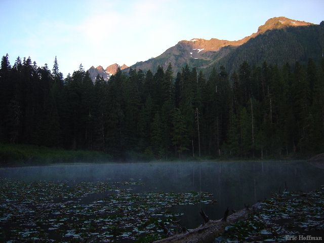
We arrived at Elk Lake where we would spend the next two nights. Other than the fact that we had it to ourselves, the lake was a bit of a disappointment (moldy tasting water and lily pad on all sides) but our spirits were high. Perhaps a better alternative is the Martin Creek Camp. Less than a quarter mile before reaching the lake, there is a good water source, it is a bit more private and it is the last camp where campfires are allowed, providing there isn't a burn ban in effect.
|
Elk Lake on Summit Day |
|
|
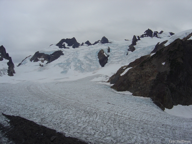
We awoke around 6:00am the next morning and departed camp around 7:00. In 2.4 miles we arrived at Glacier Meadows which doesn't appear to be much of a meadow. We continued another 0.2 miles to the summer Ranger Station and signed out in a register just beyond. In a short distance we reached a junction and took the left fork through meadows toward the lateral moraine of the Blue Glacier. We arrived at the moraine (c.5000') and got our first real look at the glacier and Mount Olympus. The skies where blue with only a few high clouds.
|
The Blue Glacier |
|
|
From the moraine we could see a slow moving party of three on Snow Dome. We headed up the moraine for a couple hundred yards then descended to the glacier a couple hundred feet below. We started up the left side of the glacier then crossed easily to a rock gully on the west side. The gully, then slabs provided easy access to a portion of the Blue Glacier known as Snow Dome. After climbing to the top of Snow Dome and evaluating the glacier we decided to rope up even though the glacier is not heavily crevassed in this area. We continued up the crest of Snow Dome then traversed left to a pass (c.7200 feet). We crossed through the pass then climbed as close to the cliffs on our rate as crevasses allowed (even though we went through the pass we were still on the Blue Glacier) . After about a quarter to half mile from the pass we climbed scree and easy rock to a high notch in a false summit.
|
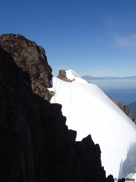
The Summit of Olympus from the Notch |
|
|
After a short descent on scree we climbed a short 50-55 degree snow pitch then descended to a small saddle where we gained the rock. Unfortunately, a slow party of three from Austin Texas were busy belaying up what appears to be the most feasible completion of the climb. We started up the arete from the saddle on easy class 2 and 3 rock then along side the Texas party in a sometimes slabby, class 4 gully. Finally, the leader of the Texas party reached the summit and was belaying the other two climbers who were too busy comforting one another to climb the 30 to 40 feet of class 4 near the top in anything that resembled a reasonable amount of time.
"Remember what you do when you go rock climbing. Look for the foot holds, look for the hand holds" said Texan number 3 to Texan number 2.
"Look for the tape!" yelled Sergio.
Sergio cut in behind Texan number 2 and quickly free climbed to the summit while Texan number 3 complained about Sergio knocking sand in his eyes. I waited and watched Texan number 3 search for holds from two feet away...waiting...waiting...waiting. I wanted to tell him to take the stairs but refrained. Texan number 3 finally reached the summit with some innovative moves on the broken rock. Finally, It was my turn...I took the stairs and quickly joined Sergio and the 3 Texans on the summit.
|
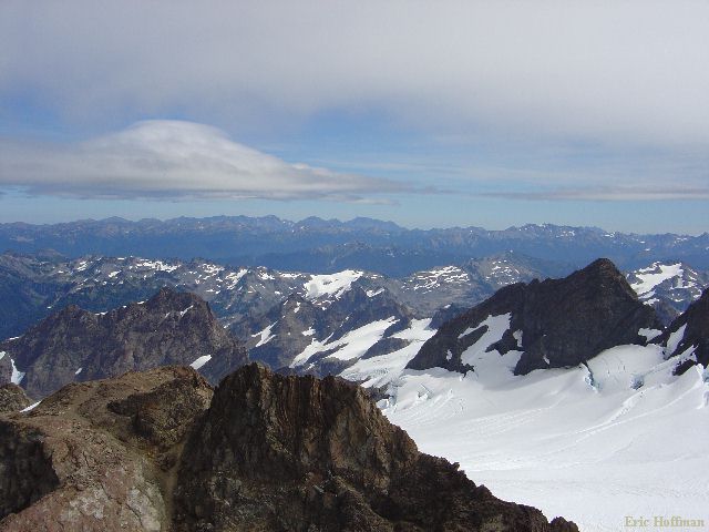
The Bailey Range from the Summit of Mount Olympus (the snowy peaks in the foreground) |
|
|
|
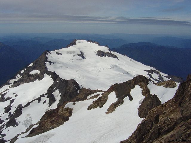
Mount Tom from the West Peak of Mount Olympus |
|
|
After patching things up with the Texans, we made one rappel down the class 4 section using their 50 meter rope (our 30 meter probably would have sufficed). We tied into our rope and put on crampons for the descent to Snow Dome. Once there we unroped and glissaded back to the slabby area below Snow Dome and above the lower portion of the Blue Glacier. We reached camp a few minutes after 6:00pm to find two parties had set up camp at the lake.
I awoke early the next morning but stayed in my bag. Not long after, I heard the unmistakable sound of a bugling bull elk. It was far away the first time I heard it. By the 3rd time I heard it, it was close. I got up to investigate. A couple hundred feet up the trail I spotted several cows and finally the bull. After they disappeared into the brush, I retreated to camp. The bull let out a final bugle, close enough this time to wake Sergio. We broke camp and departed around 8:00am, arriving at the Hoh River Visitor's Center just after 1:00pm. I am happy to report that it didn't rain while we were in the rainforest.
|
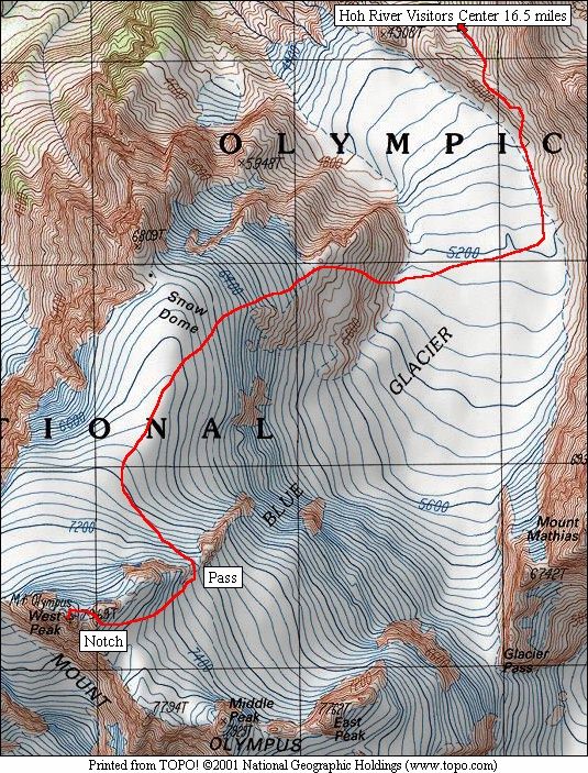
The Blue Glacier Route |
|
|
References:
Climber's Guide to the Olympic Mountains; Third Edition; The Olympic
Mountain Rescue; Pages 163-166
Climbing Washington's Mountains; Jeff Smoot; Pages 356-361
Custom Correct Maps; Mount Olympus, WA Climbers Map; 2001
Topo! Washington; Map Courtesy of www.topo.com