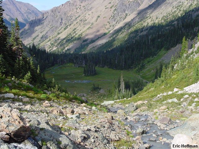
The meadows between Royal Lake and the upper basin
This was a venture into Royal Basin, said by many to be the best the Olympics has to offer. I haven't seen enough of the Olympics to make a statement like that, but I assure you that Royal Basin in not the worst that the Olympics has to offer. There are a couple of options to get to the trailhead. If you are coming across the Hood Canal Bridge, then it is best to continue nearly to Sequim. Turn left on Louella Road (signed "Dungeness Trailhead") and drive about a mile to Palo Alto Road (becomes FSR 28). Turn left and continue on the paved road. A portion of FSR 2860, the road that goes to the "Dungeness Trailhead and beyond, has been permanently closed but there is a good detour route that is only slightly longer. From Palo Alto Road turn right onto FSR 2880 and continue past Dungeness Fork Campground to the junction with FSR 2870. Take 2870 (technically a left turn but more like straight ahead) to the junction with 2860. Go right on 2860 to the Dungeness Trailhead. If you happen to be taking 101 through Quilcene, there is a shorter road that may save a little time. Turn left on Lords Lake Loop Road which becomes FSR 28. There is a detour via FSR 2810 that rejoins 28 in a few miles. Continue until reaching pavement and drive about another mile to FSR 2880 then continue as describe above.
Now that the messy drive was over it was time to take in some nature. I started hiking the Upper Dungeness Trail (FST 833) around 8:30am. The trail through old growth reaches Royal Creek and the junction with the Royal Basin Trail (FST 832) in one mile. FST 832 follows Royal Creek through more old growth forest then finally starts climbing a bit. Around 4000' the trail begins crossing some open rocky and brushy areas then reaches 5100 foot Royal Lake at 6 miles. Royal Lake is small and not necessarily spectacular but better things were just ahead.
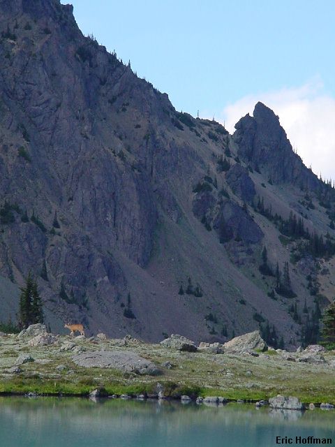
After circling the lake to the opposite end, I continued to shelter rock, an enormous blob of pillow lava that has a large overhang. From there the trail continues to a large open meadow and on to the upper basin. There is a waterfall that drops into the meadows and there were four deer grazing on a grassy hillside.
|
The meadows between Royal Lake and the upper basin |
|
|
The trail climbed along a stream to reach the large upper basin. I could have easily spent the day exploring the upper basin and maybe popping up to Surprise Basin, but I had my sights set on other things...
|
Life in Royal Basin |
|
|
|
Other Things... Mount Deception from the tarn in upper
Royal Basin |
|
|
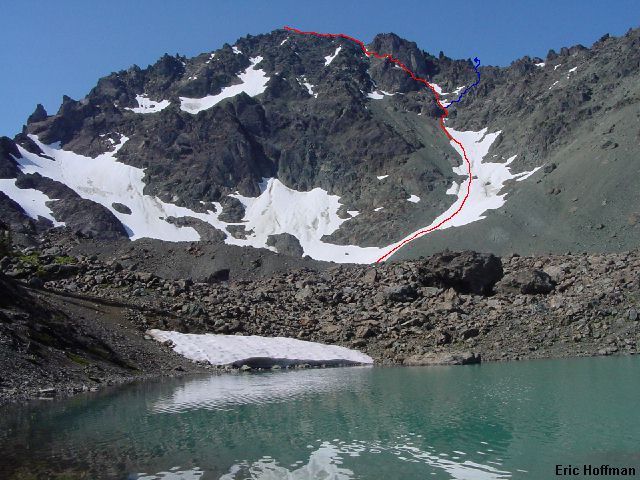
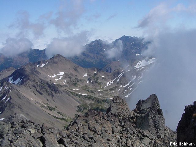
I followed the trail to a tarn. The upper basin is really something, surrounded by high peaks like Clark, The Needles and Deception. I was looking to climb Deception, the third highest peak in the Olympics, and it was clear that conditions were not ideal. The route ascends the snow finger on the right to steep hard mud and somewhat loose class 3 rock covered with scree. The normal route ascends to the low point in the ridge crest then traverses the Deception Glacier (easy) and climbs to the saddle between Deception and Gilhooley Tower in a 45 degree snow gully. From there, it is a hike to the summit. I however, was going to try the Honeymoon Route, a variation rated Grade I, class 3 but feels harder. This route climbs nearly to the low point but then takes a left branching snow gully (mostly melted out). At the top of the gully I traversed left then climbed another steep snow and rock gully to the the summit ridge. The route was a combination of loose rock, hard mud, scree and snow. After a scary climb, however, I was rewarded with some excellent views.
|
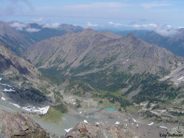
Royal Basin from 7,788 feet |
|
|
|
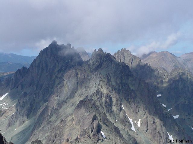
The Needles from the summit of Mount Deception |
|
|
|
Upper Deception Basin and Mount Constance from Mount Deception |
|
|
There was no way I was going to descend the Honeymoon Route so I descended the ridge nearly to Gilhooley Tower. The snow gully was nearly melted out but was not terribly long or difficult and the run-out was safe. After reaching the low point between Mount Deception and Martin Peak, I traversed left ward on loose rock and slowly descended, this is not a good place to slip, reaching the top of the snow finger. This is a climb that would clearly be better with a lot more snow and I wouldn't necessarily recommend climbing from Royal Basin under the current conditions.
When I reached upper Royal Basin it was after 4:00pm. The distractions in Royal Basin and the slow, tedious climbing had eaten up a lot of time, but I wandered around a small corner of the basin anyway. Deer, marmots and myself enjoyed a snack in solitude and the late afternoon sun. I had seen three people descending from the basin when I hiked in and had seen no one since. When I reached the Dungeness Trailhead I still had only seen three people. Tourist season is over.
References:
Climbers Guide to the Olympic Mountains, Third Edition; Olympic Mountain
Rescue; Pages 132-133, 135, 136-137
Climbing Washington's Mountains; Jeff Smoot; Pages 379-382