Lower Horseshoe Basin
Total Distance: c. 60 miles
Total Elevation Gain: c. 17,800 feet
High Points: Cascade Pass (5392'), Mount Buckner (9112'), Park Creek Pass (6100'), Mount Logan (9087')
Low Points: Cascade Pass Trailhead (3600'), Park Creek Trailhead (2300')
Camps: Upper Horseshoe Basin (7000'), Glacier Moraine near Park Creek Pass (6200')
This trip began at the Cascade Pass trailhead and my primary objectives were Mt. Buckner and Mt. Logan, two of Washington's non-volcanic peaks reaching over 9000 feet into the skies of the North Cascades National Park. Permits are required for overnight stays in the park and may be obtained at the Marblemount Wilderness Information Center which opens at 7:00 am.. My permit included one night in the Mt. Buckner XC zone, another in the Mt. Logan XC zone and a final night at Flat Creek Campground.
From the trailhead (3600') I began the journey with the 3.7 mile hike to Cascade Pass (5392'). From here I continued 3 more miles to the junction of the Cascade Pass and Horseshoe Basin trails(3600'). In a mile and a half the Horseshoe Basin trail arrives in Lower Horseshoe Basin.
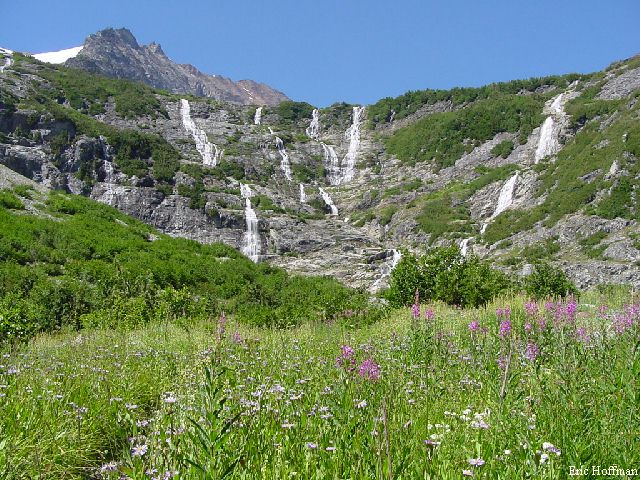
Aside from all the waterfalls and wild flowers there is another attraction, the Black Warrior Mine (4800'). The mine entrance is located behind a waterfall and is easily spotted by the tailings and mining debris scattered about. While the area I was here to explore was above, I was told one can go quite deep into mine shaft.
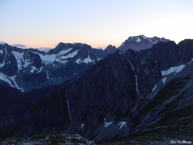
|
Lower Horseshoe Basin |
|
|
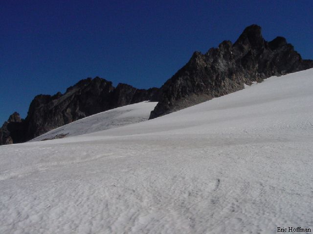
The ideal location to camp for an ascent of Mt. Buckner via the SW route would be in Lower Horseshoe Basin but camping is prohibited there. This forces climbers to camp at the Basin Campground, 3 miles from the lower basin, or in the upper basin (Mt. Buckner XC zone). According to the Beckey guide and other sources, there is an old mining trail that ascends into the upper basin. Good luck finding it. No doubt finding it would make the ascent simpler, but I finally gave up and headed straight up the rocky and brushy slopes of the basin. After several hundred feet the slope eased and I found myself in a maze of scrub cedar trees. Finally at about 6500 feet I reached open ground. There are few flat spots in the area for a bivy and I finally ended up making my own in one of the few remaining snow patches at 7000' and settled in for the night.
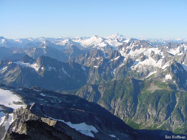
|
The view from 7000' in Upper Horseshoe Basin |
|
|
The route up the SW slopes of Mt. Buckner is on snow, talus and scree and ends with a short class 3 scramble. After ascending a couple hundred feet of talus, I put on crampons and headed up the frozen snow (35-45 degrees). The snow reached well up the mountain to about 8400'. After that it was mostly on scree and eventually reached the South Ridge a couple hundred feet below the summit. The scramble was the easiest part of the climb with fairly solid rock and little exposure. The view was spectacular.
|
A look south from the summit of Mount Buckner |
|
|
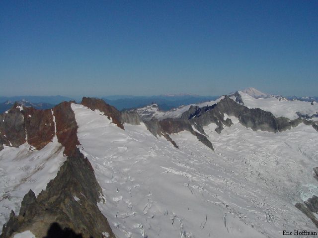
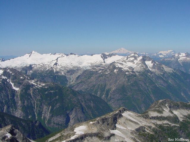
|
The Boston Glacier and much more |
|
|
After descending from the summit and gathering my bivy gear I headed for the lower basin. I knew I did not want to go down the way I had come up and there were no really attractive options. The safest option seemed to be to traverse SE and descend into the lower basin from the east. Whether it was the safest or not I cannot say, but it is probably safe to say that it was the brushiest (over 2 hours to descend 1500').
After licking my wounds and cooling off at Miners Creek I headed back to the Cascade Pass Trail and began the descent into the Stehekin River Valley. I arrived at Cottonwood Camp, 2.4 miles from the Horseshoe Basin trail and the beginning of the Upper Valley Road. The first 3 miles of the road have been closed due to a washout. Beyond the washout a 2.5 mile hike down the road brings you to Park Creek Camp, Flat Creek Camp and the Park Creek Trailhead (2300').
An eight mile hike up the Park Creek Trail leads to Park Creek Pass. If it is hot, plan a stop at two mile camp and enjoy the natural air conditioner. At six miles, the trail begins to open up and the east slopes of Buckner are revealed.
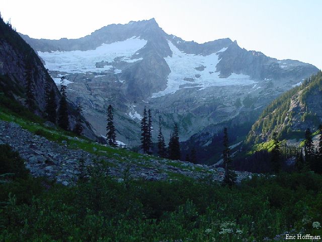
|
Mount Buckner from the Park Creek Trail |
|
|
From Park Creek Pass the Thunder Creek Trail descends to the north, in about a half mile reaching a flat area below a moraine. Here a path can be found that makes a long rising traverse toward Mt. Logan. Rather than beginning up the path, I ascended to the terminal moraine above where I found a good bivy site complete with running water. The next day I began the climb of Mt. Logan by traversing to the path.
Following the path and traversing west around point 8546' at an elevation of about 6500' and into a large basin. Cross the basin, gradually gaining elevation until reaching snow SE of point 8248' that can be climbed nearly to the southern margin of the Fremont Glacier at 8000'. From here the way is obvious. Cross the flat southern neve past the middle summit of Logan, then ascend (crevassed and icy) toward the saddle between the middle and main summit. A snow arete between two wind cirques allowed the easiest access to the rock. There is a deep moat here but it was only about a foot wide. Once on the rock, climb to the saddle via a gully and ledges (class 3-4). From the saddle the route traverses the east side of the summit ridge on exposed ledges (generally easy and solid, class 3) passing a notch then a false summit. The final 5-10 feet to the summit is on a bit more challenging class 3-4 rock. There was one small snow patch on the traverse that was easily avoided.
|
The Fremont Glacier and the summit of Mount Logan |
|
|
|
The NW view from the summit of Mount Logan |
|
|
Once off the rock I quickly descended the glacier, crossed the talus basin and traversed back to my bivy site. My next camp was supposed to be at Flat Creek Camp near the Park Creek Trailhead on the Upper Valley Road. When I arrived there at 7:00 pm it was still really hot and the flies were swarming. My options were to be eaten alive, get in my bivy and dehydrate or to keep hiking. I decided to keep hiking. This meant hiking another 14 miles to the Cascade Pass Trailhead making it a 28 mile day. By 12:30am I was at my car, 61 hours from when I had left.
NOTE: With better snow and a rope, a better (shorter and with less elevation loss) route from Upper Horseshoe Basin to the Park Creek Trail exists. A gully from the Buckner-Booker col can be taken to the Buckner Glacier (appeared moderately steep and crevassed) then the moraine followed to the area of the Buckner Camp on Park Creek.
NOTE: Shorter approaches are possible if Logan is the only destination. These include the Thunder Creek Trail and an approach from Stehekin to the Park Creek Trailhead via shuttle bus.
References
Cascade Alpine Guide Volume 2, second edition; Fred Beckey; Pages 306-308,
311-313
Selected Climb in the Cascades Volume I; Nelson/Potterfield; Pages 124-127
100 Classic Hikes in Washington; Spring/Manning; Pages 84-85